Back مقاطعة أوكلاهوما (أوكلاهوما) Arabic Oklahoma County, Oklahoma BAR Оклахома (окръг, Оклахома) Bulgarian ওকলাহোমা কাউন্টি, ওকলাহোমা BPY Comtat d'Oklahoma Catalan Oklahoma Gông (Oklahoma) CDO Oklahoma County CEB Oklahoma County, Oklahoma Welsh Oklahoma County German Condado de Oklahoma Spanish
Oklahoma County | |
|---|---|
 | |
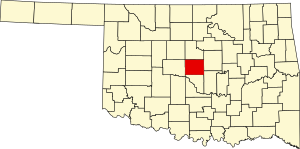
 Location within the U.S. state of Oklahoma | |
 Oklahoma's location within the U.S. | |
| Coordinates: 35°29′N 97°32′W / 35.48°N 97.53°W | |
| Country | |
| State | |
| Founded | 1890 |
| Seat | Oklahoma City |
| Largest city | Oklahoma City |
| Area | |
| • Total | 718 sq mi (1,860 km2) |
| • Land | 708.82 sq mi (1,835.8 km2) |
| • Water | 9.6 sq mi (25 km2) 1.3% |
| Population (2020) | |
| • Total | 796,292 |
| • Density | 1,123/sq mi (434/km2) |
| Time zone | UTC−6 (Central) |
| • Summer (DST) | UTC−5 (CDT) |
| Congressional districts | 3rd, 4th, 5th |
| Website | oklahomacounty.org |
Oklahoma County is a county located in the central part of the U.S. state of Oklahoma. As of the 2020 census, the population was 796,292,[1] making it the most populous county in Oklahoma. The county seat is Oklahoma City,[2] the state capital and largest city. Oklahoma County is at the heart of the Oklahoma City metropolitan statistical area.
Oklahoma County is one of seven counties in the United States to share the same name as the state it is located in (the other six being Arkansas County, Hawaii County, Idaho County, Iowa County, New York County (Manhattan), and Utah County), and the only one of the seven to contain the state capital, and one of two to contain a city of the same name as well.[3]
- ^ "Oklahoma County, Oklahoma". United States Census Bureau. Retrieved May 20, 2023.
- ^ "Find a County". National Association of Counties. Archived from the original on May 31, 2011. Retrieved June 7, 2011.
- ^ Joseph Nathan Kane; Charles Curry Aiken (2005). The American Counties: Origins of County Names, Dates of Creation, and Population Data, 1950-2000. Scarecrow Press. ISBN 978-0-8108-5036-1.
